Vermont Business Magazine As part of a voluntary Federal Aviation Administration (FAA) grant program, the Burlington International Airport (BTV) will release a draft updated noise exposure map. These maps are required for airport officials seeking federally-funded noise mitigation grants, and are meant to help address the neighbors and community concern about aircraft noise. This updated noise exposure map, or “NEM” will lead to changes regarding FAA recognized aircraft noise exposure and allow BTV to continue to have access to federal dollars for noise mitigation projects. The NEM uses a FAA-approved joint use methodology to account for the noise impacts of all airport activities.
The draft NEM document will be presented at a public meeting on Monday, November 9 at Chamberlin School in South Burlington between 6:00-8:00 pm. Comments received before 4:00 pm on Thursday, December 10 will be incorporated in the final submission to the FAA.
"We believe it is easier for the public to understand the noise impacts of all flights and other airport operations by having one methodology that takes into account all airport activity,” said Gene Richards, Aviation Director at BTV. “While some members of the public may be surprised to see their home within the sound contours on the Noise Exposure Map for the first time, the wider contours perpendicular to the runway may, over time, allow the airport and the FAA to offer additional noise mitigation supports – such as better insulation and air conditioning – to more members of the community than we can today.”
FAA regulations, specifically 14 Code of Federal Regulations, Part 150, guides land use planning on and around airports, taking into account the impact of all aircraft noise. The regulations provide a methodology and guidance for airport operators to prepare documents of aircraft noise and land use – these are referred to as “noise exposure maps” or NEM. The preparation of noise exposure maps is one step in the process to alleviate sound impacts, such as installing soundproofing materials in federally-eligible properties. The airport completed its first NEM in 1990, and the FAA accepted NEM updates in 1997 and 2006. The airport applied for and received a grant in 2012 from the FAA to conduct the noise exposure map update study. The airport hired consultant HMMH to conduct this noise exposure map study.
This new noise exposure map will help airport officials and surrounding neighborhoods better plan for the future. While the new maps show a modestly smaller area within the identified sound contour than the 2010 baseline United States Air Force EIS contour map, the new resulting noise contours are wider perpendicular to the runway and shorter parallel to the runway compared to the 2006 and 2011 NEM because the current Air National Guard mission sets and engine settings have changed since the last NEM. The draft document provides further details. The updated map expands the number of homes potentially eligible for federally funded noise mitigation, relative to the 2006 and 2011 noise exposure maps, but does not directly increase the number of homes purchased with FAA dollars. The airport will pursue other mitigation for homes not purchased, in particular sound insulation.
The draft NEM document is available HERE and at Burlington International Airport and www.btv.aero for review and comment. See LEGEND for map below.
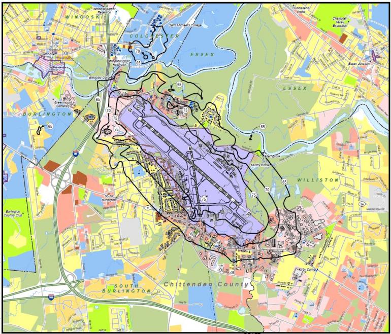
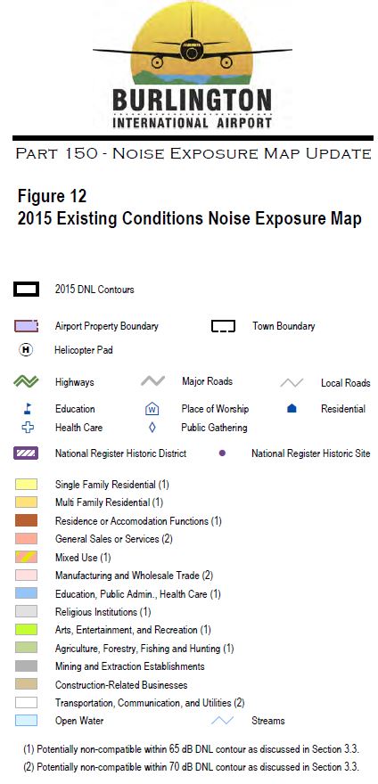 The document is also available for review at the Airport’s offices during business hours.