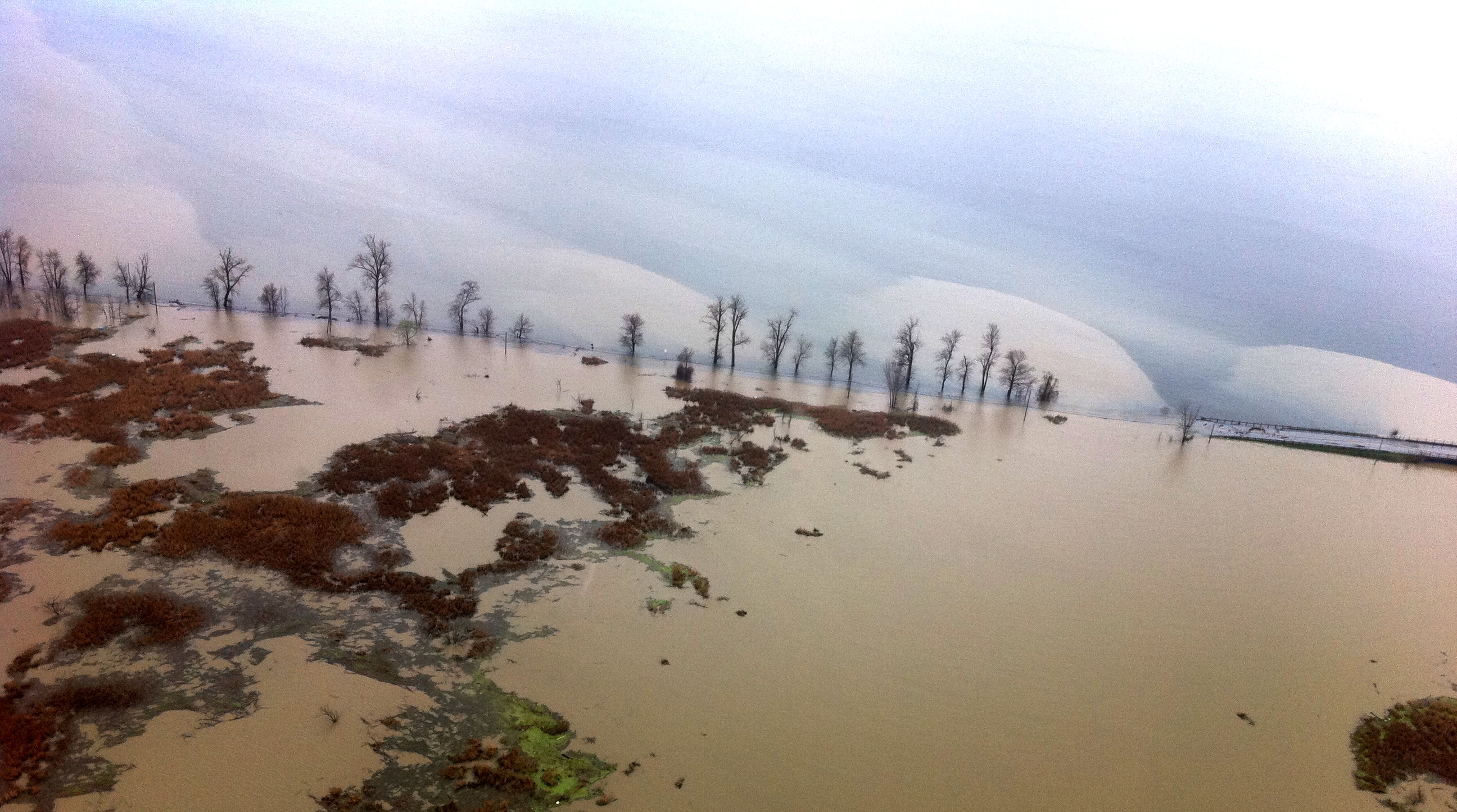
Vermont Business MagazineA few months before Tropical Storm Irene devastated much of central and southern Vermont in August 2011, rain and snow melt caused tributaries to swell, resulting in the highest-ever Lake Champlain water levels. Along with record flooding along the coasts of Vermont and New York, waters spilled north up theRichelieu River to cause vast damagein Quebec ($72 million CD). That event resulted in a cross-border study of how to mitigate future flooding. TodaytheInternational Lake Champlain-Richelieu River Study Board released itsdraft Work Plan. It is available for public feedback untilJuly 28, 2017. The Study Board will host public meetings in Vermont, Québec and New York in July to share information about the study and seek public input on the draft Work Plan.The study would be 5 years in length and cost approximately $5.5 million US ($7 million CD).
The Study Board was appointed by theInternational Joint Commissionto undertake the work outlined inthe 2013 Plan of StudyOption B, to more fully explore the causes, impacts, risks, and solutions to mitigate flooding in the Lake Champlain-Richelieu River basin.
The study’s main objectives are to:
-
Develop and recommend the implementation of a bi-national, real-time flood forecasting and flood inundation mapping system to prepare for and mitigate the impacts of floods.
-
Recommend measures – structural and non-structural - to mitigate flooding and the impact of flooding throughout the basin.
-
Determine public, community and stakeholder desirability of the proposed measures to mitigate flooding and the impact of flooding throughout the basin.

Thepublic comment periodbeganJune 27, 2017 and will continue untilmidnightonFriday, July 28, 2017. Members of the public are encouraged to submit comments on the Work Plan, either online athttp://www.participateijc.org/champlain-richelieuor by email at[email protected]. Additionally, members of the public are encouraged to attend the public meetings and chat with Study members.
Public meetings will be held at the following locations:
- Tuesday, July 11:Public Meeting in Burlington, Vermont
The University of Vermont, Davis Center, Livak Ballroom 590 Main Street, Burlington, Vermont 05405
6:00pm- Informal discussion with Study members;7:00pm - 9:00pm- Public Meeting
- Wednesday, July 12:Public Meeting in Saint-Jean-sur-Richelieu
Corporation du Fort St-Jean, Pavillon Dextraze (salle Grand Fort) 15, rue Jacques-Cartier N, Saint-Jean-sur-Richelieu, Québec J3B 8R8
6:00pm- Informal discussion with Study members;7:00pm - 9:00pm- Public Meeting
Thursday, July 13:Public Meeting in Plattsburgh, New YorkState University of New York, Yokum Hall Room 208 101 Broad St, Plattsburgh, New York 129016:00pm- Informal discussion with Study members;7:00pm to 9:00pm- Public Meeting
Executive Summary
 The record setting floods of 2011 in Lake Champlain Vermont/New York U.S. and the Richelieu River in the province of Quebec Canada spurred the U.S. and Canadian governments to work together to identify how flood forecasting, preparedness and mitigation can be improved in the Lake Champlain-Richelieu River (LCRR) basin. In July 2013, the International Joint Commission (IJC) submitted the LCRR Plan of Study (PoS) to the Governments of Canada and the United States. The 2013 PoS outlined the work required in the LCRR basin in order to explore potential floodplain management solutions and to provide a range of structural and non-structural flood prevention and mitigation measures. In 2015, the IJC LCRR Technical Work Group completed some initial tasks identified in the PoS. In 2016 the U.S. and Canadian governments decided to pursue Option B as described in the PoS; this decision lead to a reference to the IJC to conduct Option B activities, and for IJC to create the International LCRR Study Board to oversee and conduct studies and work related to Option B. This Work Plan describes how these activities would be done, when and their costs.
LCRR Study Board was created in 2017 and is comprised of an equal number of members from the U.S. and Canada. In addition, a full study governance structure has been developed to include study co-chairs, technical work advisory groups, public outreach and communications groups, study co-managers, and information technology and management support. The Study Board will be responsible for overseeing and managing the study and ensuring that the government mandates are met.
 The work outlined in Option B of the 2013 PoS and the associated 2016 governments’ references to perform the work include seven objectives:
1. Evaluating the causes and impacts of past floods, especially the event of 2011.
2. Assessing the possibilities offered by the floodplain best management practices.
3. Evaluating possible adaptation strategies to the expected future variability in the water supplies.
4. Developing and making recommendations for implementing, as appropriate, an operational, real-time flood forecasting and flood inundation mapping system for the Lake Champlain-Richelieu River watershed.
5. Conducting an in-depth study of current social and political perception on structural and other mitigation measures to support and confirm the desirability of potential structural mitigation solutions.
6. Performing a quantitative and qualitative assessment of potential flood management and mitigation measures (non-structural and/or moderate structural works) and their impacts on important resources of the system: the wetland and fauna, recreational, domestic, industrial and municipal uses of water, shoreline and floodplain built environment and agriculture.
7. Developing resource response models that include basic indicators for water resources response to water levels fluctuations, with special attention on the data inventory and identification of thresholds. Climatic projections, wind wave and ice models, additional new data for the evolution of watershed physiographic characteristics over time and a complete digital terrain model should also be produced to allow the planning, evaluation and ranking of potential flood mitigation solutions, using a shared-vision approach.
The seven major objectives of the study will require a multi-disciplinary and interactive strategy for completing study goals and this approach is emphasized in the work tasks. A unique feature of this study is the important emphasis placed on understanding social, political and economic drivers for flood mitigation and forecasting.
Source: Lake Champlain Basin Program 7.6.2017www.lcbp.orghttp://ijc.org/files/tinymce/uploaded/LCRR/WPdraft20170626.pdf