

Submitted by tim
on
Preparedness Resources for Vermont Businesses
Important Message:
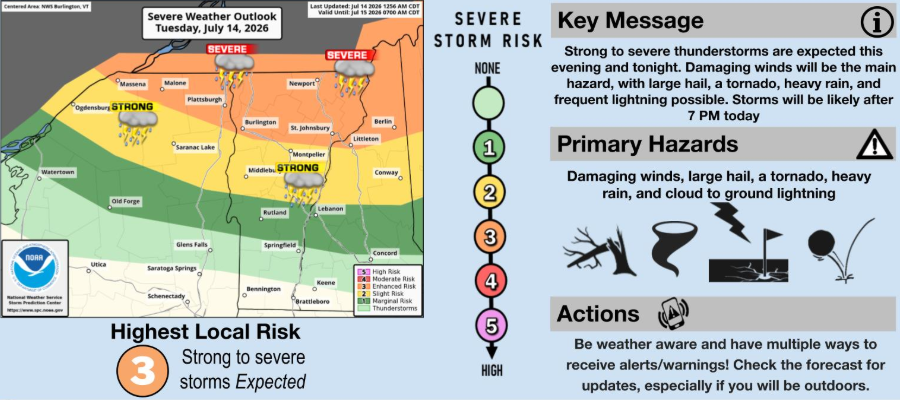
The National Weather Service has issued a severe weather outlook for Tuesday, July 14, 2026, placing much of Vermont under a Level 3 (Enhanced) Risk for strong to severe thunderstorms.
These storms are expected to move through Vermont this evening after 7:00 PM.
Key Hazards to Expect:
- Damaging winds (the primary hazard, which may lead to downed trees and power outages)
- Large hail
- Heavy, localized rainfall (with potential for localized ponding or flooding)
- Frequent cloud-to-ground lightning and a risk of isolated tornadoes
Action Steps & Business Continuity Resources
- Stay Informed: Keep multiple ways to receive real-time alerts and warnings active on your mobile devices. Monitor local forecasts closely, especially if you have staff working outdoors.
- Secure Your Property: Secure outdoor signage, patio furniture, and loose materials that could become hazards in high winds.
- Report Utility Issues: Keep your local utility provider's contact information handy to report downed lines or outages immediately.
- For emergency preparedness materials, please visit Vermont Emergency Management.
Stay safe tonight.

7.14.2026. Vermont Department of Economic Development Agency of Commerce and Community Development
To support vital journalism, access our archives and get unique features like our award-winning profiles, Book of Lists & Business-to-Business Directory, subscribe HERE!
 Vermont Business Magazine