by Timothy McQuiston, Vermont Business Magazine The Department of Public Service has created an interactive map that shows the results of a drive test of mobile wireless coverage in the state. After reviewing providers’ maps that purport to show the extent of their coverage, the Department undertook a drive test of all major roads in the state to collect data and assess where mobile wireless service is actually available from a consumer perspective. The interactive map shows considerably less service than providers claim, which could result in more money for carriers to expand service in Vermont.
The Federal Communications Commission, through the Mobility Phase II program, intends to direct up to $4.53 billion in support through reverse auctions to bidders that commit to offer mobile wireless service in eligible areas throughout the nation. When the program was announced only a small amount of territory in Vermont was eligible. The FCC authorized a process by which states could challenge asserted wireless coverage in apparently ineligible areas. The data developed through the Department’s participation may render significantly more territory in Vermont eligible for the Mobility Phase II grant process.
Led by Telecom Infrastructure Specialist Corey Chase, the DPS found 4,186 square kilometer blocks with inadequate mobile coverage. The major wireless carriers had reported to the FCC that there were only 1,300 (typically in the mountains or very remote areas where the carriers would not cover regardless because of cost). The DPS balked at that number and thus conducted its own speed test. They found more than triple the number of blocks that did not meet the 5 Mbps standard.
Chase drove over 6,000 miles across Vermont in October and November to gather data. He said he concentrated on villages and towns and found 750 blocks within those population centers with wireless coverage less than 5 Mbps. The rest of the 4,186 are "provisionally" confirmed as having insuffient coverage along the state's roadways. The provisional designation refers to the fact that he basically drove through that particular block along the highway and didn't "zig-zag" through the sidestreets, if there even were any, to gauge coverage.
Some of those underserved blocks included ones in Stowe, Montpelier, Waterbury Center and even, he said, in Winooski, one of the most densely populated areas of the state.
“Access to wireless communications services is very important in our rural state. I am hopeful that our challenge will be fully sustained by the FCC. And I hope that companies will seek grants to serve the expanded territory made eligible through our efforts in the forthcoming FCC grant program.” said Public Service Commissioner June Tierney.
Under the FCC rules for the program, areas without access to wireless service providing 5 Mbps will be eligible for the grants. To identify these areas, the FCC directed service providers to submit confidential information depicting the extent of existing service and used this to identify eligible areas. This process resulted in only 1,310 square kilometers of eligible areas in Vermont, out of a total territory of approximately 25,000 square kilometers.
Clay Purvis, Director for Telecommunications at the Public Service Department said, “Anyone who drives Vermont’s roads experiences the industry’s coverage data is not accurate. Many of the areas in Vermont shown as served at 5 Mbps on their coverage maps actually lack sufficient coverage to even make a call. Our staff tested coverage in Vermont along all major roads, downtowns and village centers to gather information to challenge the coverage shown on the FCC Eligible Areas map.”
The FCC required challengers to conduct speed tests, at their own expense, on smartphones to rebut the coverage asserted by the providers. The DPS began the process of identifying eligible blocks last March. Chase said they then needed to identify a good app, have it modified and then do all the driving.
In fact, the results across the country, not just in Vermont, were such a discrepancy from the private maps the carriers provided to the FCC that the FCC has opened an investigation into whether the carriers were being honest about their wireless coverage claims. The DPS, because the reports were private, don't know which carriers reported what; all they know is the total coverage the carriers collectively claimed.
“The good news is that our tests newly identified 1,607 square kilometer blocks where service at 5 Mbps is available from at least one provider. Even better, the 4,186 one-kilometer square blocks where we were able to mount a challenge to the asserted coverage should now be eligible for the Mobility Phase II program.” Purvis said.
Through the CoverageCo process, in which about 195 2G microcell radios were installed along important rural thoroughfares and in unserved villages. The CoverageCo business ultimately failed last year. But the state did identify where wireless coverage was most needed from a human perspective. And with this new DPS speed test completed, the state now knows and can prove to the FCC and the carriers where new, sufficient technology needs to be deployed.
With over $4.5 billion available to carriers across the nation to upgrade wireless coverage, Chase expects carriers to take advantage, despite having to spread the wealth across 50 states.
"It's still quite a bit of money," he said. The FCC does not have a firm timeline of when upgrades could begin, but Chase expects the FCC not to sit on that money for too long before awarding grants.
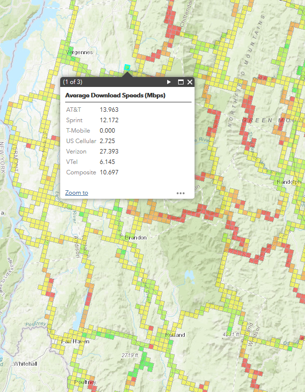
Detail of drive test map showing wireless coverage in western Vermont from Poultney to Vergennes along major routes. Green is good and red is bad. Click image for full interactive map and see more links below.
A report describing the initiative, statistics, static maps (PDF) and an interactive map depicting the drive test information are posted on the Department website at:
https://publicservice.vermont.gov/content/mobile-wireless-2018-drive-test .
Tutorial: a video tutorial explaining how to use the interactive map
Static Maps: PDF maps for each carrier, depicting coverage asserted by each provider along with the results of the drive tests.
FCC Initial Eligible Area interactive map
CoverageCo Related Article, VBM October 2018:
Stakeholders cautiously hopeful for ‘new’ CoverageCo