
As it is this year, August 28, 2011, was a Sunday. But on that day, Tropical Storm Irene hit Vermont. It resulted in six deaths, $733 million in damages, 117,000 power outages, a dozen towns and villages were cut off, and over 500 miles of roads were damaged or destroyed. Photo of Route 4 east of Rutland courtesy CVPS.
by Gaye Symington, High Meadows Fund We find out who we are when we are pushed to our limits. In August 2011, the power of water pushed Vermont hard – and revealed the power of our Vermont community. Tropical Storm Irene was a momentous event in Vermont’s history, and the response to Irene showed our remarkable identity as a people and as neighbors who care for each other. In the time since Irene, our state has confronted the new reality of more frequent and intense storms. We have been working together as a state and as communities to be better prepared and more resilient together. However, we have more to do.
Vermont has unique challenges because of our topography and development choices. We live in the valleys along the rivers, and in rural, forested areas along dirt roads. This settlement pattern means it is critical to consider our upstream and downstream neighbors when we make decisions about how to interact with our rivers and other waterways and with our watersheds.
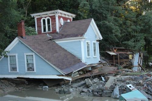 Home in Bethel. US Fish 7 Wildlife Service photo.
Vermont’s remarkable social capital was evident in our extraordinary response after Irene devastated dozens of communities. Where neighbors united and worked as allies, communities made faster progress in recovery and rebuilding. We need to apply that spirit of community and social capital to identifying our risks and reducing our vulnerability to future storms.
The power of water in our mountainous state was a wake-up call that brought out the resourceful power of our people to unite, be smart and prepare for our new reality.
Tropical Storm Irene has taught the state of Vermont several lessons. We still have more to achieve to act on those lessons:
River corridors must be protected so that rivers can stay in equilibrium and don’t damage valuable investments.
Rivers naturally form in an “S” shape, and they need space to meander so they can stay in balance. This natural movement helps to reduce the river’s power during a flood event. Floodplains also help to allow natural overflow during times of heavy rain or snowmelt. Land use policies, practices and choices must always consider and protect the river corridor in order for Vermont to be “flood ready.” By giving the river the space it needs to slowly progress, it will evolve into its least erosive form.
Several towns have adopted or are preparing river corridor protection standards to restrict development alongside rivers and to give rivers room to move. However, we still have more to do as a state, as only one out of four towns have limited floodplain development in this way.
Watershed communities must be connected with a strong sense of upstream/downstream relationships.
Vermont’s special challenge with regard to flooding is erosion, rather than inundation. Our big challenge is not so much that huge amounts of water are flowing, but rather that rivers that are out of equilibrium and have been eroded cause the water to move faster and more powerfully. River experts suggest we work to “slow it, spread it, sink it” when thinking about water movement.
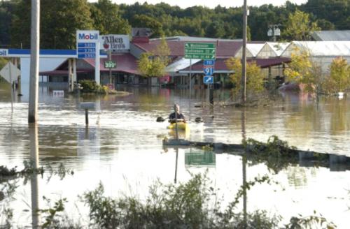 Allen Brothers store in Bellows Falls. VBM photo.
Upland forests absorb precipitation and delay streams and rivers from becoming overwhelmed by runoff in a storm. Town-level strategies and actions can help to protect the river corridor and help the entire watershed community. Local waterway erosion maps inform communities about safe development, and show where
opportunities are to protect residents and infrastructure such as housing, community buildings, bridges and roads. Some communities have begun to proactively identify and address their risks by restoring the banks between land and water, conserving river corridors and floodplains, and installing green infrastructure.
On the other hand, artificial barriers contain the river, creating more force as the water moves downstream, and putting downstream communities at risk. Watershed community members have to take their upstream and downstream neighbors into consideration as they make decisions about land use along waterways.
Low income Vermonters are the most at-risk
Fifteen percent of the homes damaged or destroyed in Tropical Storm Irene were mobile homes or manufactured homes, even though they make up only 7% of the housing stock of Vermont. Many mobile home parks are located in areas that are vulnerable to flooding and erosion because that land is typically less expensive. Almost half the mobile home stock in Vermont was built before 1990. Homes of this age are showing significant signs of deterioration. A partnership between UVM and the Champlain Valley Office of Economic Opportunity has been assessing the risks and developing approaches to improve the resilience of Vermont’s mobile home parks.
Vermont’s great strength is its remarkable identity and social capital, and we must leverage this capital to prepare for the future.
The idea of “Vermont Strong” emerged from Vermonters working shoulder to shoulder with each other to assess the damage, care for each other and help individuals, business and communities recover after the storm. We need to apply this same resourcefulness and community awareness to becoming better prepared and resilient, not just responding to disasters after they occur. Toward that end, communities are exploring ways to improve communications among planning and conservation commissions, disaster preparedness experts, first responders, and elected leaders.
Vermonters must be ready for more frequent and intense storms, as well as other effects of climate change.
What we have learned is that Vermont communities must know the risks they face and plan together as watershed communities for the new reality we are all facing. Over the last 30 years annual precipitation in Vermont has increased by between 9 inches (Northeast Kingdom) and 5 inches (southern Vermont). Over the past 60 years the frequency of one-day heavy precipitation events has increased 74% in the northeast. In the five years since Irene, Vermonters have experienced eight FEMA declared disasters from serious storms. As the climate changes, these trends will continue and worsen.
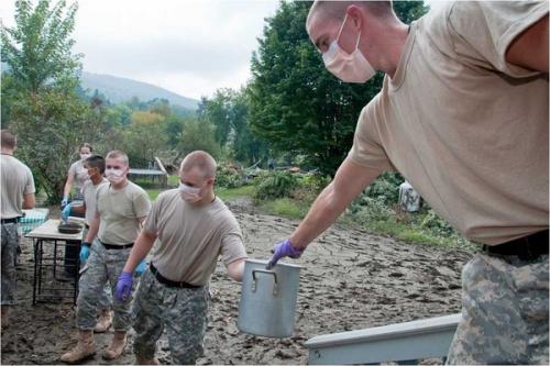 Norwich University cadets assist in recovery. Norwich photo.
Vermont communities recognize that to be resilient, they need to be aware of these risks and base their planning on these future trends, rather than on how things have been in the past. Many tools have been developed or refined since Tropical Storm Irene, and towns are beginning to use these tools to incorporate flood readiness into their planning. However, this effort must be ongoing and ubiquitous to ensure that Vermont is ready for future flooding and other harsh weather events.
Tropical Storm Irene surprised Vermont with the power of the rain and the flooding it caused. As a state and as communities, we are now committing to being prepared and to make critical changes – so we can leverage our own power and potential, and so when future storm events happen, we are ready.
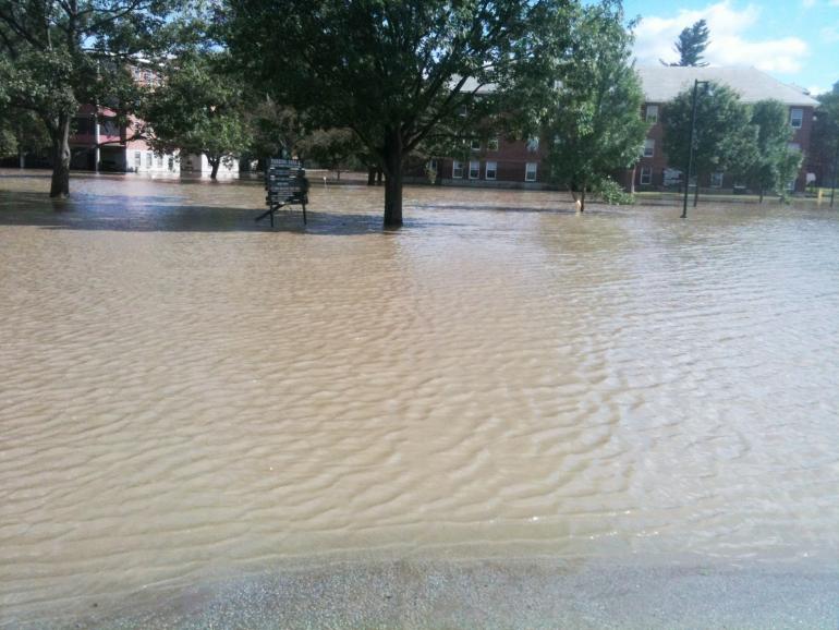 Waterbury state office park. Vermont ANR photo.